LEAVES FROM THONDAIMANDALAM
THIRUPPORUR: BETWEEN THE HILL AND THE LAKES
Thirupporur is conceived and built in the grand style of a capital town. The site itself seems to have been carefully selected and landscaped to express the grandeur of a town designed to be the cultural capital of a region. On the west of the town there is a row of low hillocks and rocks. From the foot of these hillocks the ground gently slopes down to an almost continuous row of erys and thangals, big and small ponds, broken only by a flower garden at one point and a couple of fields at another. Beyond these erys and the fields in their command there is the vast open stretch of the coast. The town is perched on the strip of land between the hillock on the west and the long front of water and greenery sloping off into the coastal river and sands on the east. The water front formed by the erys and thangals in fact turns around on the north and south ends of the town to meet the hillock and close in the town from three sides.
To form an impression of the lay-out of the town it is best to turn off the highway, into the Madam Teruvu near the Chidambara Swami matham, and take the narrow path that runs through the town parallel to the highway. This north-south path is part of the original road to Mahabalipuram. The present highway bypasses the town and again meets this path on the south of the town.
Madam Teruvu goes around Chidambara Pandaram kulam and joins the north-south path which at this point runs below the west bank of Kusavan thangal. This thangal occupying about 2.5 hectares according to the eighteenth century records is one of the main irrigation sources of Thirupporur. Towards the east and visible from the north-south path is Ichan thangal, another major source of irrigation for the fields of Thirupporur. Adjoining Kusavan thangal and almost touching its south bank lies Vedarpuri kuttai, a relatively small unlined pond.
Opposite Vedarpuri kuttai there is a small temple now known as the Senkalani Amman kovil. This is probably the temple mentioned in the eighteenth century records as Vaanarvasiamman kovil. There are nine temples in these records. Most of these were small except Kandaswami kovil, which occupied about 5 acres of land, and Kailasanathar kovil on the hill that occupied more than 1 acre. Vempadi Vinayagar temple towards the north of the hill seems to have a fairly big compound today. In the eighteenth century records the area occupied by this temple was only around 300 square yards. Pidariyar Mullaiyammai temple adjoining Vempadi Vinayagar temple however was somewhat bigger covering about 1000 square yards.
From the Idaiyar kuttai the north-south path runs along a few fields and reaches another kulam, known these days by the name of Nalla Chetty Kulam. This is perhaps the Thiruvengadam kulam of the eighteenth century records. This square tank lined with brick and stone, covered by thick foliage of peepal and other trees, and with a wide flat bank on which there stands a small Amman temple, seems to be a place designed for rest and relaxation. Nalla Chetty kulam has the luxurious ambience of the carefully constructed water bodies and parks in modern urban landscape, and the climate near the kulam is pleasant and soothing even on a hot summer afternoon.
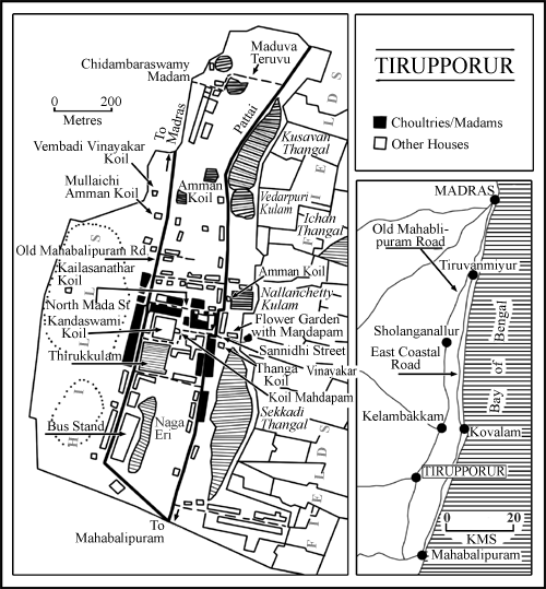
(click on map to enlarge)
Beyond Nalla Chetty kulam the north-south path meets North Mada street, running east to west. This is a wide street with a clear view of Kailasanathar kovil on the hill on the west and the open fields on the east. Further down there is Sannidhi street. This is even wider than North Mada street with even grander view on both ends. On the west Sannidhi street runs into the 16 legged Mandapam of Kandaswami kovil, and behind the Mandapam there rises the high gopuram of the temple. On the east the street simply slopes down into the vast coastal spaces.
Almost opposite the temple, on the north-south path, there is a wide enclosure, which was a flower-garden in the eighteenth century. Inside this garden there is a circular mandapam with a high platform and a flat roof standing on a multitude of pillars. The temple is clearly visible from the high platform of this beautiful mandapam. Outside the enclosure there is a smaller less elaborate mandapam again with a clear view of the temple. This mandapam, and a few thatched huts next to it, standing around a hundred yards from the main gate of the temple, now serve as the fish and meat market of Thirupporur.
From here onwards the north-south path runs along a long thangal, at the southern end of which is localted the colony of Thirupporur. In the eighteenth century the colony had 8 Pariar households on 10 acres of land. The thangal next to the colony, Sekkadi thangal, is now largely silted up and seems almost dry. This was another of the major sources of irrigation for Thirupporur. Beyond the colony the path meets the highway. On the west of the path near this point was Naga ery which has now been filled up and is used as the bus-stand.
The four streets around Kandaswami kovil it seems formed the capital complex of Thirupporur. These streets in the eighteenth century housed mathams of various communities. Mathams were supposed to be places of high learning, which may also have provided a place of stay for the pilgrims and arranged for the performance of various rituals connected with pilgrimage. In the current village maps these streets are shown as occupied by choultries. Many of the mathams in fact have now been converted into private choultries, and even shops or houses. But most of them have simply decayed and are lying in ruins.
Buildings on North Mada street and on a small lane off Sannidhi street are in a relatively better state of repair, and many of them have been reconstructed to function as choultries. Some of these seem to be fairly active. For example the two storied Sengunthar Mudaliar Chhatram near the temple seems to have many visitors. Vanniyar Chhatram on North Mada street seems to be equally active.
On North Mada street there is a matham run by a Sangham of the Thondaimandalam Adisaiva Vellala community. The Sangham according to the caretaker of the matham has 4000 members. He explains that a matham is a place where only members of a particular community may come and stay, while chattrams and choultries are open to anyone who can pay. There are no rituals or pujas performed inside this matham now, but the matham still offers the afternoon puja in the temple on behalf of the community that it represents.
Adisaiva Vellala matham, and perhaps also the Sengunthar Mudaliar and Vanniar Chattrams, seem to be the only active community places in Thirupporur today. The Kovil matham run by the Thirupporur Adhinam, who is also the chief Dharmakarta of the temple, and Chidambara Swami matham also function effectively. But these latter are not really community mathams, and are mainly connected with the management of the temple and the samadhi of Chidambara Swami. In the eighteenth century however almost all the chhatrams and choultries of today were mathams of one community or the other.
This community based organisation of places of pilgrimage and learning is one of the more interesting features of the eighteenth century information. Of the 178 houses in Thirupporur then 46 were either mathams or houses of the pandarams who looked after the mathams, or performed specific services for the temple. Almost all these mathams were mathams of specific communities. There was thus a Vannar matham, a Vanniar matham, a Chetty matham, a Komati matham, a Kammalar matham, a Kanakkupillai matham, and so on. There were even separate mathams of subcommunities within communities. There were thus mathams of Maligai Chettys and of Ilai Vanniars. There were also mathams after the names of certain families or certain localities, but even these latter were probably patronised by only a specific community from the named locality.
Thus though Kandaswami of Thirupporur was provided for from the budgets of the localities around it, individuals from those localities interacted with the temple only as members of specific communities or subcommunities. Thirupporur was thus a capital town in another sense of the term, it was the place where various communities of the region had their cultural centres. These community centres were all connected with Kandaswami of Thirupporur, and this connection was expressed through the various rituals and pujas that these centres performed in the temple. Yet they were also independent centres of learning, religion and culture for their particular communities.
The complex organisation of Thirupporur perhaps reveals something important about the ways in which a decentralised polity is knit together in various centres where the decentralised units interact together through their representative institutions. But this polity built upon layers of self-contained yet mutually interwoven social, cultural, geographical and political units is not easy to unravel. What is however clear is that when this complex polity functioned it did so gloriously. The beautifully landscaped and grandly built town of Thirupporur, even in its decay, stands witness to that glory.
J. K. Bajaj and T. M. Mukundan
Centre for Policy Studies
Madras
September 1991